A Fourth Dynasty monument.
Principal carving is most plausibly associated with Khafre’s building project. The quarry and temple sequence support that attribution; an exact first-carving date remains unresolved.
Examine the argument →Giza, Egypt · An open investigation
How old is it? Who carved it? What lies beneath? Explore the discoveries, competing explanations and unfinished investigations—and follow the evidence as far as it goes.
The proposed ages / oldest to youngest
Oldest proposals first. Entries are evenly spaced for reading, not proportional to elapsed time. The opening scale marker is not a proposed exact construction date. BCE dates and broad period labels retain the precision of each argument.
Manichev and Parkhomenko’s proposed chronology; no direct construction date.
Hancock and Bauval’s proposed symbolic epoch; an astronomical interpretation, not a measured carving date.
Schoch’s later proposed age for the core; the head is treated separately.
The initial estimate in this research tradition, distinct from Schoch’s later proposal.
Reader’s geological argument; a broad historical placement, not a numerical dating interval.
Stadelmann’s full Khufu attribution; the writeup distinguishes Lehner’s narrower allowance for an earlier start.
Dobrev’s proposal is documented in scholarship by 2001. The writeup traces the 1999 article, documentary and boat-pit evidence; the linked paper reports his hypothesis.
Conventional attribution for principal carving, supported by quarry and temple relationships. These are reign dates, not measured construction endpoints.
Robert and Olivia Temple’s later alteration hypothesis, not an age for the original body. The linked source is the author’s book description.
The natural-landform experiment and Hall of Records tradition have no specific construction date established in this register; explore them in the theory cards below.
01 / Get your bearings
Principal carving is most plausibly associated with Khafre’s building project. The quarry and temple sequence support that attribution; an exact first-carving date remains unresolved.
Examine the argument →Keep these as separate investigations. An older surface, a geophysical anomaly and a concealed archive would each require different evidence.
Compare the alternatives →A first research edition covering major archaeological, geological and esoteric claim families. It is an expandable inventory, not a claim to have found every theory or every permit record.
Read the research dossier →02 / Age, builders & purpose
Dates below belong to their proponents. They are not one combined age range, and inclusion does not imply equal evidential support.
10 theories and interpretations
Fourth Dynasty · c.2558–2532 BCE reign context
Egyptian Ministry; Mark Lehner and AERA
Temple masonry, the enclosure quarry and the neighboring royal complex form a connected building sequence. This makes Khafre the strongest candidate for the principal carving campaign.
The reign window is a historical attribution, not a measured start and completion date. A contemporary dedication naming the original sculptor or commissioning king is not established here.
Principal carving and the adjoining construction sequence, not the geological age of the limestone.
Lehner and Aigner matched the geological beds in temple core blocks to the Sphinx enclosure. Quarrying around the reserved rock mass supplied the adjacent Sphinx Temple. This connects the monument and temple through material and construction sequence, rather than simply through their proximity.
AERA combines those matches with the relative sequence of the Sphinx Temple and Khafre Valley Temple. Its conclusion assigns most of the Sphinx to Khafre while allowing that Khufu could have begun it. The Ministry’s attribution supplies the reign context shown on the timeline; it is not a radiocarbon or other laboratory determination.
Reader challenges aspects of the conventional sequence and argues for an earlier monument incorporated into the later complex. Our assessment: a proposal for an earlier phase must explain the surviving quarry and temple relationships, not merely point to an absence of a dedication. Conversely, construction sequence does not identify the day or year when carving began.
The Khufu and Djedefre entries now separate portrait identity, commissioning ruler and construction phase. Our assessment: absence of a royal dedication leaves room for debate, but is not positive evidence for either alternative. A convincing earlier attribution must accommodate the same quarry and temple relationships supporting Khafre.
Start with “Stone by Stone” and the geological block correlations; this is an authored synthesis, not the complete field archive.
Access record · S233Read alongside the block matches to understand how relative order supports attribution.
Access record · S234Official monument entry; the displayed dates are a reign context.
Access record · S232Reader’s response offers a competing reconstruction of early development.
Access record · S238Comparison reviewed 2026-11-06. Paragraphs marked “our assessment” or “our comparison” are this collection’s analysis.
← Return to the dating timelineAudit block matches, construction joints and securely associated original cutting deposits.
Fourth Dynasty · before Khafre
Rainer Stadelmann; a narrower earlier-start possibility discussed by Lehner
Stadelmann attributes the monument to Khufu through landscape and royal iconography. Lehner’s allowance for a possible Khufu beginning is a separate, narrower proposal.
The original 1999 argument is now available. Its relative chronology and stylistic identifications remain disputed; no contemporary dedication identifies the commissioner.
Stadelmann’s proposed Khufu commission of the monument, distinguished from a possible earlier phase in a predominantly Khafre project.
Stadelmann’s 1999 paper concludes for Khufu, not merely an earlier start (pp.878–879). He treats the later royal stelae as insufficient construction testimony (pp.868–869).
He interprets Khafre’s southward causeway alignment as accommodation of an existing Sphinx. He places the reserved rock within Khufu’s quarry landscape, but explicitly concedes that quarry location alone does not prove the attribution (pp.869–870).
His comparisons emphasize a fully pleated nemes without a frontal band, headdress wings and uraeus, and an originally beardless chin. He assigns the surviving beard fragments to a later addition and contrasts the proposed original with Khafre’s statuary. He also questions photographic facial overlays and acknowledges the limited securely identified Khufu comparison material (pp.872, 875–878).
An older quarry does not itself date the carving. A causeway avoiding a rock mass can be compatible with several construction sequences. Stylistic dating needs securely attributed comparanda and control for restoration; identifying a portrayed king does not identify the commissioner. These are tests of the inference, not a claim that a new excavation has refuted it. AERA’s Khafre attribution has an independent material case: enclosure-to-temple block correlations combined with the neighboring temples’ relative order. It must not be reduced to the damaged Dream Stela.
Lehner allows a possible beginning under Khufu while assigning most work to Khafre. That limited allowance should not be counted as endorsement of Stadelmann’s full attribution. The unresolved issue is which phase, if any, can independently be tied to Khufu.
CRAI 143(3), 1999, pp.863–879; DOI 10.3406/crai.1999.16044. Read the page-specific arguments above in Persée’s text view. Some illustrations are rights-masked.
Access record · S272Read “Stone by Stone” and distinguish Lehner’s qualified earlier-start possibility from Stadelmann’s conclusion.
Access record · S233The temple sequence is the key independent check on an earlier royal commission.
Access record · S234Comparison reviewed 2026-11-06. Paragraphs marked “our assessment” or “our comparison” are this collection’s analysis.
← Return to the dating timelineTest the proposed royal typology against securely attributed sculpture and the quarry–temple construction sequence.
Fourth Dynasty · Djedefre’s reign
Vassil Dobrev; scholarly citation by 2001, television coverage in 2004
Dobrev proposed that Djedefre commissioned a Sphinx representing Khufu, his father, in a royal and solar program.
The proposal is now traced to a pre-television scholarly citation and a specific 1999 publication lead. Boat-pit inscriptions support Djedefre’s activity at Khufu’s complex, not a direct Sphinx commission. The original article and authenticated documentary footage remain unaudited.
A proposed commission by Djedefre representing Khufu, rather than a monument representing its commissioning ruler.
Verner’s 2001 chronology paper, p.377 n.128, already attributes to Dobrev a Sphinx representing deified Khufu, commissioned by Djedefre and incorporated into Khafre’s complex. His references lead to Dobrev’s 1999 article, La IVe dynastie: un nouveau regard, especially p.18. IFAO’s contemporary publication list independently confirms the article in Égypte, Afrique & Orient 15, November–December 1999, pp.2–28. This corrects any impression that the hypothesis first appeared in 2004. The original article itself has not been recovered.
The surviving references provide a precise checking route: Verner n.126 points to pp.17–18 for the added boat pits and filial cult; n.128 points to p.18 for the Sphinx attribution; the Louvre identifies p.19, fig.12 as its Djedefre head E 12626; Verner n.116 points to p.20 for the disputed boat-pit count-date attribution. These are other sources’ references to Dobrev, not a transcription or direct reading of his pages. Their full wording, qualifications and image captions remain unverified.
The Louvre’s collection record identifies this head as Djedefre and gives its findspot as his funerary complex. Its bibliography explicitly cites Dobrev 1999, p.19, illustration 12. This makes one illustrated object independently traceable. Our comparison: an image from Djedefre’s own complex can inform royal portrait studies, but its presence in the article does not establish how Dobrev used it or connect its manufacture to the carving at Giza. The missing page must be read before attributing a specific visual comparison to him.
Broadcast’s 9 December 2004 production report identifies Sphinx Unmasked as an Atlantic Productions programme, with post-production at Oasis and a scheduled Five transmission on 14 December. That matches the date in the contemporary report calling the programme Secrets of the Sphinx. Our inference: these are likely related release titles; identical edits are not established. Serengeti’s distributor catalogue lists Sphinx Unmasked as a standalone special, while its series catalogue includes The Sphinx Unmasked in Unearthing Ancient Secrets. The screener requires registration/login; no authenticated footage or end credits were inspected.
IFAO records Dobrev’s 19 January 2004 Giza interview for Seven Wonders of Ancient Egypt, credited to Atlantic Productions, Discovery Channel and Channel 5. This remains a distinct production record: shared personnel and subject do not prove that the interview became the December documentary.
An indexed transcript of a third-party upload titled The Sphinx Unmasked attributes three arguments to Dobrev: the causeway avoids an existing Sphinx (10:07–10:27); Khafre’s bearded statues contrast with the Sphinx (10:30–10:51); and an approach from the south places Khufu’s pyramid behind the Sphinx in profile (11:32–12:51). These passages make the reasoning more inspectable. Direct retrieval returned 410 Gone, so footage, speaker identification, transcript accuracy and edition remain unverified.
The 2004 report attributes a filial and solar explanation to Dobrev: Djedefre commissioned an image of Khufu. Our assessment: a Khufu likeness, even if accepted, does not distinguish a lifetime Khufu commission from a posthumous one by Djedefre. The southern viewpoint is a spatial interpretation, not a dated construction deposit. A specific Djedefre commission requires an additional chronological or dedicatory link.
Abubakr and Mustafa’s original 1971 report, The Funerary Boat of Khufu, pp.9–11 and fig.6, publishes marks on roofing blocks and identifies gangs named for Djedefre. The authors interpret the blocks as quarried during his reign. Our assessment: this is material evidence connecting Djedefre’s workforce to Khufu’s funerary complex. Its find context is the boat pit south of the Great Pyramid, not the Sphinx enclosure; it cannot directly date the Sphinx.
Verner, pp.375–377, connects Dobrev’s proposal for added southern boat pits with a cult of Khufu, but describes the disputed count-date attribution and incomplete documentation. His notes refer to Dobrev pp.17–20. Gundacker’s 2015 discussion, n.183, gives the counterargument: blocks could have been prepared under Khufu and installed by Djedefre’s crews after the funeral, so the count-date need not belong to Djedefre. Our assessment: activity under Djedefre, the duration of his reign, and a Sphinx commission are three separate inferences. The boat-pit evidence establishes no automatic bridge between them.
IFAO provides Dobrev’s Considérations sur les titulatures des rois de la IVe dynastie égyptienne, BIFAO 93, pp.179–204. Its catalogue labels the volume 1994; it is often cited as 1993. Metadata were inspected, but the full oversized PDF was not audited. It is a lead into his royal-titulary research, not an identified technical publication of the later Sphinx attribution.
The causeway argument needs to explain the enclosure quarry and both temples’ relative construction sequence. The beard argument needs to establish the statue’s original condition and whether royal portrait conventions are exclusive enough to identify a reign. AERA’s case combines geological block matches and building order, providing a stronger construction link than a visual alignment alone. Neither the new interview record nor the transcript supplies a contemporary inscription naming Djedefre as commissioner.
The publisher’s browsable archive reaches back to issue 49 (2008); Mir@bel likewise records online coverage from that issue, with restricted full text. The requested issue 15 (1999) is outside that listed coverage. No readable copy of pages 17–20 was recovered in this search. We can compare the documented boat-pit evidence with AERA’s quarry-and-temple sequence, but cannot yet present Dobrev’s exact original reasoning as inspected. The next retrieval target is a library or publisher copy of the 1999 article, including captions and notes.
The BnF now provides an issue-specific retrieval route. From the main journal record, follow the linked Egyptes record and open En savoir plus for shelfmark 4-O3A-2971. Conservation unit 4 explicitly covers 1999 (N12–15), at Tolbiac, Rez-de-jardin, magasin, and offers reproduction under conditions. The catalogue describes the copy as presumed present. This locates issue 15 in a library collection; it does not mean its pages have been digitized or read in this audit.
Prepared request (not sent): Please supply a research scan of Vassil Dobrev, “La IVe dynastie: un nouveau regard”, Égypte, Afrique & Orient 15 (November–December 1999), pp.2–28, especially pp.17–20, including figures, captions and notes. Please include the issue title/contents page and confirm pagination: IFAO lists pp.2–28; the Louvre lists pp.3–28. BnF shelfmark 4-O3A-2971, conservation unit 1999 (N12–15), linked catalogue record cb34459790j. Please confirm availability, reproduction conditions and any cost before proceeding.
The publisher’s contact page provides a second inquiry route through the Centre d’égyptologie and names Cybèle and Institut Khéops as resellers. Its advertised digital archive begins in 2008, so a subscription alone is not a verified way to obtain the 1999 issue. No current issue-15 stock or readable scan was confirmed. The original argument remains unread; the new finding is a specific library holding and a practical route to request it.
Verner (2001), pp.375–377, notes116,126,128. Original PDF text inspected. Secondary for Dobrev’s thesis; an original argument for Verner’s own chronology.
Access record · S276IFAO report, printed p.563: Dobrev, La IVe dynastie: un nouveau regard (1999), pp.2–28. Publication confirmed; article not recovered.
Access record · S277Louvre E 12626 (excavation CH 1). The museum cites the article as pp.3–28, whereas IFAO gives pp.2–28; both identify the same title and issue. The object record is accessible, the original article remains unrecovered.
Access record · S282Abubakr and Mustafa (1971), pp.9–11, fig.6. Read the boat-pit marks in their own find context; do not relabel them as Sphinx inscriptions.
Access record · S280Gundacker (2015), n.183, citing Dobrev pp.19–20. Indexed passage checked; full chapter not audited.
Access record · S281Broadcast, 9 December 2004: Atlantic / Oasis, scheduled Five showing on 14 December. A production and schedule report, not a recording of transmission.
Access record · S278Standalone special plus series listing. Screener access is gated; catalogue wording that claims the mystery is solved is promotional.
Access record · S279BIFAO 104, activity report: Vassil Dobrev, Communications. Indexed entry inspected; full report not read. Confirms date and production credit only.
Access record · S273Indexed passages at 10:07–12:51; third-party upload, direct page unavailable. Do not treat it as an authenticated broadcast transcript.
Access record · S275Background royal-titulary study; the more specific Sphinx retrieval lead is now Dobrev’s 1999 article via Verner (S276) and IFAO (S277). Full text remains unaudited.
Access record · S274Retained for the publicly reported Djedefre/Khufu proposal; journalism relaying another newspaper.
Access record · S241Enclosure-to-temple block correlations.
Access record · S233Test a pre-Khafre commission against relative building order.
Access record · S234Publisher archive and Mir@bel coverage begin at issue 49 (2008). This describes the checked online collection, not proof that issue 15 has never been digitized elsewhere.
Access record · S283Open En savoir plus on the linked Egyptes record: unit 4, 1999 (N12–15), shelfmark 4-O3A-2971. Conditional reproduction route; no scan obtained.
Access record · S284Contact route only; issue-15 availability unconfirmed. Digital subscriptions advertise coverage from 2008.
Access record · S285Comparison reviewed 2026-11-06. Paragraphs marked “our assessment” or “our comparison” are this collection’s analysis.
← Return to the dating timelineRecover Dobrev’s 1999 article, especially pp.17–20, and the distributor’s authenticated documentary edition; compare the cited objects and building phases with the Khafre sequence.
Before the Fourth Dynasty; no numerical measurement interval
Colin Reader
Reader emphasizes stronger degradation at the western enclosure and runoff pathways changed by later quarrying. He places the proposal within early Egyptian development, rather than an otherwise unidentified Ice Age civilization.
Earlier rain and earlier activity do not by themselves date the statue. The reconstruction depends on which quarries and drainage features existed together. Reader’s model and groundwater alternatives remain contested.
An Early Dynastic predecessor within Egyptian history; not an Ice Age construction date or a measured numerical interval.
Reader’s 2001 paper argues that the distribution of enclosure degradation requires rainfall runoff in addition to other processes. His reconstruction links erosion to the landscape before later quarrying altered the water catchment. The proposed earlier construction follows from that sequence, rather than a calculation of age from a constant erosion rate.
Vandecruys proposes groundwater seepage and enhanced salt weathering as an explanation compatible with the conventional chronology, also invoking the surrounding archaeological context. Reader’s 2006 reply disputes shallow groundwater as the principal cause while allowing limited groundwater and other weathering processes. The disagreement concerns which mechanism explains the spatial pattern and how that pattern relates to construction.
Evidence for earlier runoff is not by itself evidence that the statue had already been carved. The decisive issue is whether the relevant erosion demonstrably affected artificial surfaces before independently dated alterations to drainage. Reader’s argument should be compared with the Khafre sequence on those specific relationships; it should not be grouped indiscriminately with much older proposals.
Author-hosted scan located; indexed introduction and abstract inspected. Full PDF retrieval exceeded the browser limit, so figures have not been audited.
Access record · S271Publisher-indexed abstract inspected; direct PDF retrieval failed. Do not treat this as a complete reading of the critique.
Access record · S253Introduction, section 2 and conclusions are the route into the dispute; the reply is not independent corroboration.
Access record · S238Author-permitted reproduction; useful alongside the journal paper.
Access record · S237Comparison reviewed 2026-11-06. Paragraphs marked “our assessment” or “our comparison” are this collection’s analysis.
← Return to the dating timelineCompare same-bed erosion distributions and independently phase the drainage-changing cuts. Read the critique and reply together.
Initial c.7000–5000 BCE proposal; later c.10,000 BCE
Robert Schoch and John Anthony West
Schoch interprets weathering and seismic differences as requiring a much longer exposure history, with a dynastic recarving of the head. His later account places the core near the end of the last Ice Age.
These changing estimates are interpretations, not laboratory dates. Climate, rock durability, exposure, salts and repair history must be constrained. An older core would not automatically validate an Atlantean builder.
The proposed age of a core body, with a separate later head recarving; two successive estimates from the same research tradition.
Schoch’s retrospective identifies this as the range announced with West in 1991, based on weathering profiles interpreted against regional climatic history. It is an inferred construction chronology, not a measured confidence interval. The retrospective is a primary source for Schoch’s account of his earlier position, not a recovered copy of the original presentation.
Schoch’s current account places the core near the end of the last Ice Age. It invokes rainfall/runoff erosion and subsurface weathering inferred from seismic work, and proposes a dynastic recarving to explain the head. These are interpretations of physical observations; the two timeline dates are not independent confirmations.
Gauri and colleagues’ geological rebuttal is paired here with the original seismic publication. Vandecruys offers groundwater and salt weathering as an alternative to a much older carving. AERA presents a separate archaeological constraint from quarry and temple sequence. Our assessment: neither the presence of water nor seismic variation alone supplies a construction age without controlling for rock properties, inherited fractures and exposure history.
Schoch describes the later estimate as following additional evidence and reanalysis; that claim needs a reproducible chain from observations to chronology. Our comparison asks what changed between the initial range and the Ice Age estimate, and whether the revised model excludes a shorter history. Monumental building at another site cannot itself date a carving at Giza.
“Questioning Accepted History” distinguishes the 1991 estimate from the later position; original conference abstract not recovered here.
Access record · S256Read the rainfall, head-recarving and seismic arguments as separate inferences.
Access record · S235DOI links to Dobecki and Schoch, Geoarchaeology 7, 527–544. Abstract/metadata access only in this audit; raw waveforms not reanalysed.
Access record · S248Gauri, Sinai and Bandyopadhyay, Geoarchaeology 10, 119–133. Publisher abstract/metadata checked; full measurements not audited.
Access record · S236Indexed abstract available; complete text access remains limited.
Access record · S253Comparison reviewed 2026-11-06. Paragraphs marked “our assessment” or “our comparison” are this collection’s analysis.
← Return to the dating timelineShow that dated post-carving erosion and calibrated weathering rates exclude plausible dynastic histories.
c.10,500 BCE proposed symbolic reference
Graham Hancock and Robert Bauval
Hancock argues that the east-facing lion may evoke Leo rising at the spring equinox in that remote epoch.
Matching a selected sky configuration cannot alone establish carving time or intentional design. The identification of the constellation and the choice of epoch need independent Egyptian evidence. This is separate from geological dating.
A proposed astronomical or symbolic reference to c.10,500 BCE; such a reference would not necessarily be the time of construction.
Hancock’s own account proposes that the east-facing lion corresponds to Leo at dawn at the spring equinox in 10,500 BCE. He and Bauval also appeal to Egyptian religious texts and a proposed Leo–Horakhti identification. This is a claimed cultural connection, not simply a date returned by a sky simulation.
In his complaint about Horizon, Hancock disputes the dismissal of Egyptian recognition of Leo and points readers to Keeper of Genesis, UK paperback pp.177–189. That is an identifiable route into his supporting argument. The complaint documents his response; it does not establish that the regulator or an independent Egyptological assessment accepted the astronomical interpretation.
A sky pattern can be calculated for a past epoch, but intention and construction time require separate evidence. A later builder could refer to an earlier epoch; an eastward orientation could also have other explanations. To turn this proposal into a construction date, the constellation identification, chosen epoch and monument’s design would need independently dated Egyptian connections. A rainfall argument cannot substitute for those links.
See the section on Sphinx astronomy and Leo. It identifies the book passage, but neither the full book argument nor a regulator’s adjudication was audited here.
Access record · S239Comparison reviewed 2026-11-06. Paragraphs marked “our assessment” or “our comparison” are this collection’s analysis.
← Return to the dating timelineFind an independently dated inscription or design system linking this monument to that constellation and epoch.
Proposed earlier jackal; Middle Kingdom head recarving
Robert and Olivia Temple
The Temple proposal treats the original body as Anubis and the present face as Amenemhet II, with water held around the monument.
The author’s promotional description was checked; its complete photographic argument was not. Shape resemblance does not demonstrate a removed head. Schoch also disputes the moat explanation, showing that alternative theorists disagree.
A hypothesized Middle Kingdom alteration of the head; it does not date the creation of the original body.
The Temples’ book description proposes an original Anubis form, a face recarved as Amenemhet II, and an enclosure holding water. These concern original shape, later intervention and environmental history. Accepting one would not establish the other two.
The author presents a case based on historical accounts and visual comparisons, but the accessible description is promotional rather than a fully documented archaeological report. Our assessment: proportions or resemblance may motivate a recarving hypothesis; a securely phased recut surface would be stronger evidence for when it happened.
Schoch disputes the moat explanation in his own Sphinx account. This matters because “water erosion” is not a single theory: rainfall, groundwater and an engineered water enclosure predict different histories. Our comparison asks for independently dated recutting evidence and physical evidence of water management before assigning a Middle Kingdom event.
Primary evidence for what Robert and Olivia Temple propose; the complete book and its photographic case remain unaudited.
Access record · S240Schoch’s objection is an alternative interpretation, not a substitute for direct testing of the moat.
Access record · S235Comparison reviewed 2026-11-06. Paragraphs marked “our assessment” or “our comparison” are this collection’s analysis.
← Return to the dating timelineSeek securely phased recutting traces and physical water-retaining infrastructure; test each claim separately.
Early Pleistocene; paper discusses an age exceeding 750,000 years
Manichev and Parkhomenko, 2008 proceedings
They compare hollows to wave-cut coastal forms and associate their elevation with ancient lake levels. The paper explicitly begins from a very old age suggested by Blavatskaya.
The crucial jump is from an erosion analogy and regional water level to an already carved monument. No direct construction date or securely associated builder context is supplied. This is not another version of Schoch’s rainfall mechanism.
A claim that an already carved monument existed by an Early Pleistocene water episode; the million-year marker is only a browsing scale.
The 2008 proceedings paper opens with Blavatskaya’s claim of an age exceeding 750,000 years, then asks whether geology could support it. That number is not a laboratory result. The paper’s conclusion links the monument to an Early Pleistocene water level; it does not establish an exact date of 1,000,000 years.
Manichev and Parkhomenko interpret deep horizontal hollows as analogous to wave-cut coastal forms. They combine visual inspection, comparisons with coastal erosion and published regional lake history to argue that a large water body once affected the monument. The mechanism is wave action, distinct from Schoch’s rainfall interpretation.
The critical test is whether dated water action affected a demonstrably human-cut surface, rather than a natural outcrop later carved. Similar shape alone cannot establish the same origin or age. Local deposits, elevations and stratigraphic contacts must link the proposed water episode to the statue itself. No directly dated construction context or securely associated builder evidence is supplied by the paper.
AERA describes differential weathering of harder and softer limestone beds and ties the enclosure quarry to temple construction. A Pleistocene proposal must explain these relationships as well as the hollows. This is our methodological comparison, not a claim that AERA published a point-by-point reply to this particular paper.
Manichev and Parkhomenko, Sofia 2008, pp.308–311. Introduction and abstract identify the age claim; a third-party mirror hosts the paper. Publication does not itself validate the chronology.
Access record · S242Use the bed descriptions and quarry-to-temple argument to examine alternatives to wave erosion.
Access record · S233Comparison reviewed 2026-11-06. Paragraphs marked “our assessment” or “our comparison” are this collection’s analysis.
← Return to the dating timelineEstablish local deposits, their dates and their physical relationship to demonstrably artificial cuts; exclude differential weathering.
No construction date proposed by the experiment
Boury, Weady and Ristroph
Laboratory erosion of heterogeneous material can generate sphinx-like landforms, supporting the possibility that a natural outcrop inspired or reduced the human carving work.
The experiments use clay and flowing water as a physical analogue. They do not demonstrate that this exact process made the Giza outcrop, date its carving, or eliminate human sculpting.
Compare the model’s predictions with mapped bedrock and tool-mark evidence at the actual site.
Modern Cayce readings describe a much older lost history
Edgar Cayce; Association for Research and Enlightenment
Cayce’s readings describe records associated with the Sphinx and Atlantis. This belief helped motivate modern searches and is part of the history of exploration.
A.R.E. is a primary source for its own tradition, not archaeological confirmation. A geophysical anomaly cannot identify texts or their authors. No excavated archive is established by the reviewed material.
A documented chamber, secure access record, in-situ objects and independent dating would allow archaeological evaluation.
No theories match. Clear the search or choose All.
03 / The exploration record
Separate a completed survey from a proposed excavation, an actual passage from an interpreted signal, and a documented decision from a later retelling.
Amenhotep II’s temple and Thutmose IV’s Dream Stela belong to a later solar cult. The stela records royal engagement with an existing monument.
Unfinished / uncertain: Later restoration and religious interpretation cannot independently establish the first carving date.
Hassan’s account describes beginning work around the Sphinx after earlier difficulty obtaining permission; the precinct included remains of later occupation and worship.
Unfinished / uncertain: The original indexed passage is available, but the full monograph and its plates remain to be audited here. Institutional restrictions have a history older than the Hall of Records debate.
The report recommends follow-up surveys and drilling, explicitly allowing both natural and artificial causes for anomalies.
Unfinished / uncertain: The recommendations are plans, not proof that every proposed action happened. Link each later borehole to a specific original target before comparing outcomes.
Dolphin recalls five camera-inspected boreholes: three in the temple area and two in the surrounding platform. He reports natural cracks at the tested anomalies.
Unfinished / uncertain: At least six hoped-for holes were not drilled; Dolphin cites time, budget and protection, saying the final decision was his. He later reported missing logs and no formal report. However, Lehner cites an unpublished 1978 interim report: these are different archival questions.
Plans, elevations, restoration drawings and photographs create an inspectable record of the monument and its changing masonry.
Unfinished / uncertain: An online archive is an entry point, not proof that every permit file or subsurface dataset is public. Individual sheets remain to be joined to the claims in this guide.
Hawass reports reopening and mapping a passage remembered from Baraize’s clearance by Mohammed Abd al-Mawgud Fayed. It contained modern debris and a descending dead end.
Unfinished / uncertain: Its original date and purpose are uncertain. A real passage does not establish a Hall of Records.
Waseda’s institutional catalogue lists the non-destructive investigation. Later accounts describe interpreted subsurface features.
Unfinished / uncertain: The linked full report was not recovered. Exact geometry and locations require original plans; an IFAO catalogue identifies a relevant 1987 report.
Seismic work reported nonuniform weathering and possible subsurface cavities.
Unfinished / uncertain: Physical contrasts are inferred from signals. Their translation into an artificial chamber, a date or contents needs independent confirmation. No raw-data reanalysis was completed here.
Hawass acknowledged three weeks of surveying and the investigators’ room/tunnel interpretations. He declined drilling or digging based on anomalies, citing conservation.
Unfinished / uncertain: Original permits remain unrecovered. A reproduced statement attributed to Daniel Pullen describes a separate five-day FSU staff visit and rejects film participation; the original post is still needed. Do not assume that visiting staff establish university sponsorship of the entire expedition.
Bauval reported that further Schor licenses seemed unlikely without new evidence, while also describing an offer to release basic data subject to SCA approval.
Unfinished / uncertain: This is a participant’s account, not the signed decision. It complicates claims of a permanent ban on all work or all disclosure.
The SEG abstract reports radar profiles near the left forepaw and two dipping reflectors. Its acknowledgments credit SCA organization and permission to publish.
Unfinished / uncertain: The authors could not distinguish natural structures from artificial ones and proposed a small 3–4 m borehole. No outcome for that particular proposal was recovered; “proposed” cannot be upgraded to “cancelled.”
NOVA describes conservation work; a contemporary YSI supplier report documents four camera-inspected monitoring boreholes in early 2008 and subsequent water-level sensors.
Unfinished / uncertain: No published coordinate/trajectory match to the 2001 forepaw radar target was recovered. Nearby monitoring holes do not establish completion of that proposed test.
AERA reports a project to document old surveys and drill holes, with new mapping and radar.
Unfinished / uncertain: The published summaries do not identify which holes, if any, intersect the 2001 target. The underlying inventory is the next lead.
The AERAgram study interprets reflections near the southeast temple terrace as possible supporting masonry and suggests camera inspection.
Unfinished / uncertain: This is a separate location and recommendation, not a reported completion of the 2001 forepaw borehole.
Beneath the Sphinx / Four locations
A passage, a radar reflector and a predicted archive are different kinds of evidence. Compare whether a space exists, whether people made it, when it was made and what it contains.
Left and right refer to the Sphinx’s own sides as it faces east: left is north, right is south. The descriptions below are location guides, not surveyed boundaries or a reconstruction of tunnels.
Northwest rump · entrance at enclosure floor level
Egyptian overseer Mohammed Abd al-Mawgud Fayed remembered the opening from Baraize’s 1926 clearance and identified the stone covering it. Hawass’s 1997 account describes maps, profiles and elevations; those original drawings still need to be joined to this case file.
What would move this forward: Recover the published passage drawings and Baraize photographs; distinguish cut surfaces, natural rock and restoration masonry. Seek stratified deposits or tool-mark comparisons that could constrain its origin.
North side of the enclosure · near the Sphinx’s left forepaw
The 2001 radar survey prompted a proposed 3–4 m confirming hole. A recovered 2009 video now documents drilling explicitly described as passing beneath the north/left forepaw. This strengthens the follow-up evidence, but does not identify a completed test of the radar profiles. Proximity, hole trajectory and target intersection are separate questions.
Broad positions read from YSI p.2; not a coordinate overlay or a map of drilled trajectories.
| Well | Location | Relation to target |
|---|---|---|
| PZ/S1 | North of the left forepaw | Closest mapped candidate to the radar survey area; intersection unverified. |
| PZ/S2 | West of the rump | Different part of the enclosure; no target connection shown. |
| PZ/S3 | Along the north flank, behind the forepaw | North-side well, but distinct from PZ/S1; trajectory absent. |
| PZ/S4 | Southeast of the forepaws | Opposite side from the north-paw grid; no target connection shown. |
The 2005 author-uploaded paper contains processed profiles and a photographed survey outline, not the original acquisition archive. It specifies Malå Ramac/X3M equipment, 250 MHz antennas here, 2 cm trace spacing and about 35 cm between lines. Median filtering, frequency enhancement and migration at 0.113 m/ns produced the images. These depths depend on that velocity model. Raw traces, field coordinates and processing files were not recovered. [S259, S270]
The processing section places the first prominent features about 5 m north of the paw; the summary and conclusion say 6–7 m. Preserve both approximations until the original grid is recovered. The authors considered cross-bedding and fractures: nearby exposed fractures had comparable orientation and depth, but seemed too narrow to explain strong echoes without conductive filling. The proposed passage remains an interpretation. [S259]
AERAgram 9(1), Spring 2008, p.7 reports that Mark Lehner and Ana Tavares surveyed five drill-hole positions in mid-March for Cairo University groundwater monitoring. YSI’s 2009 account describes four camera-inspected monitoring wells and includes a location diagram on p.2. The counts differ; neither publication identifies a hole as the test of the 2001 reflector pair. Do not assume all five holes were newly drilled, or that the four and five are identical sets. [S286, S264]
Our visual reading of the original p.2 diagram is tabulated below. Orientation follows the east-facing monument: north is the side of its left paw. PZ/S1 is the relevant candidate by broad location. The diagram lacks a usable coordinate grid, scale bar and borehole trajectories; its nearby numerical labels are not used here as horizontal coordinates. Do not equate PZ/S1 with the video’s “first hole” without a cross-reference. [S264]
Heritage Key’s 3:47 video was uploaded on 15 October 2009. At 0:18–0:22, Lehner identifies the first hole as passing beneath the north/left forepaw. At 1:21–1:33 he explains a field sketch, giving a 1 m offset from the paw and a 3.20 m reference to the back claw. The transcript’s additional toe measurements need checking against the original drawing. Sampled frames show an inclined drill beside the paw. These are relative location clues, not a surveyed 3D trajectory. [S287]
At 1:44–2:02 the commentary describes solution cavities at four metres and porous, yellow, clay-like material. Hawass reports eight drillings extending about ten metres beneath the monument (1:03–1:16) and a negative hidden-space result (2:38–2:50). Lehner explicitly distinguishes work since 2008 from continued work in 2009 (2:16–2:26). The film is edited participant testimony with visible drilling and a field sketch; it is not the complete downhole video log. Four monitored wells, five surveyed holes and eight reported drillings cannot be silently treated as one inventory. [S287, S286, S264]
Bekhit, Hassan and Abd-Elmegeed’s chapter cites AEEC-CWP (2008b), Technical Report for the Drilling of Four Boreholes around the Sphinx, Video Logging and Water Level Monitoring. This is the most specific report lead yet for the monitoring holes. Its title is verified in the bibliography; the report itself and its attachments were not recovered. Do not infer that its four holes include the filmed 2009 hole. [S288]
Our assessment: a north-paw location is now supported, but intersection remains unproved. The radar grid was north of the paw; the video shows an inclined hole directed beneath it. A hole can begin nearby and pass below or beside a reflector. We need matching collar coordinates, azimuth, inclination and depth conventions, then the core or camera interval at the calculated intersection. Hawass’s reported negative result deserves inclusion, but cannot by itself resolve this specific anomaly. [S259, S264, S287]
Mohamed’s 2020 paper, p.667 reference 13, attributes the four-borehole/video-logging report to Cairo University (2008). This complements the AEEC-CWP 2008b citation. Nearby references distinguish a 2007 geotechnical report, a three-well testing report, July–October 2008 operational readings and a 2009 final report. They are separate retrieval targets. The later paper does not reproduce the requested coordinates or drilling logs. [S289, S288]
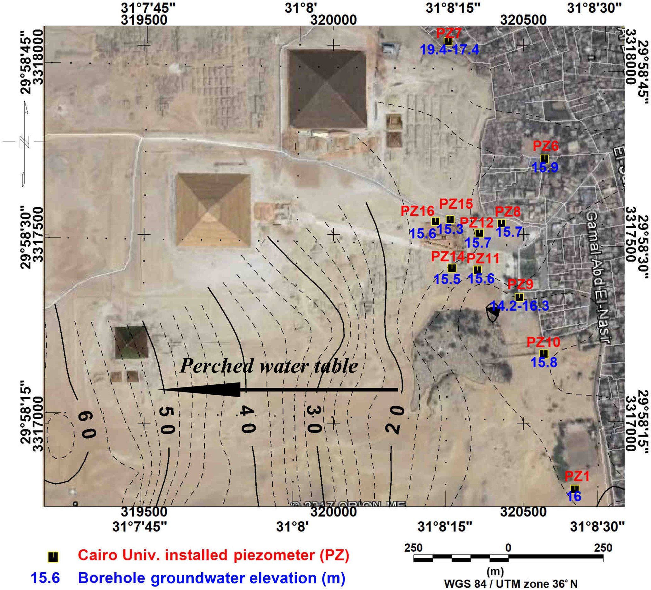
We inspected Figure 12 of Sharafeldin et al. (2019): its regional map uses WGS84 / UTM zone 36N and identifies Cairo University piezometers with labels including PZ1 and PZ6–PZ16. The blue numbers are groundwater elevations in metres. These IDs are not the YSI diagram’s PZ/S1–PZ/S4; no crosswalk to those four wells or the 2001 radar grid is supplied. The map cannot establish a metre-scale target intersection. [S266, S264]
The original 2008 report, its coordinate schedule and depth-indexed drilling/video logs remain unrecovered in this search. A valid comparison needs hole IDs and dates; collar eastings, northings, elevations and datum; azimuth and inclination or deviation measurements; and logged intervals tied to the 2001 radar grid. A 20 m hole length alone cannot show that it crossed a shallow reflector. Failure to recover a public copy is not evidence that the records were concealed.
Search or request the report under both AEEC-CWP (2008b) and Cairo University (2008), including all drawings and video-log attachments. Cairo University’s project centres are institutional leads, not verified current custodians. The 2019 paper offers its study data through its corresponding author; that is a lead for the later map data, not a promise of access to the 2008 archive. The March 2008 AERA position survey remains a separate route. No request has been sent. [S289, S288, S266, S286]
The Open Context archive describes the 1979–1983 Sphinx Project, including older water-table measurements. Its availability does not establish that the March 2008 hole survey is online. The 2007–2008 annual-report text and public publication index did not yield the requested coordinate sheet in this search. The five-hole survey remains documented by AERAgram 9(1), p.7, but its measured positions remain unrecovered. [S290, S286]
Open Context’s methodological notes place the old grid origin at N3000/E500, near the south forepaw, aligned to magnetic north on 20 February 1978. Its values decrease northward and eastward. Adding 9.331 m converts its local heights to the project’s sea-level tie. These are historical grid conventions, not borehole coordinates, and must not be applied to the 2008 records without identifying their datum. [S290]
Giza Occasional Papers 5, p.215, describes the GPMP system as true-north oriented, with the Great Pyramid’s calculated centre assigned E500,000/N100,000. It distinguishes WGS84 values from UTM36/European Datum 1950 values for some survey points. This helps explain what a future coordinate comparison must check; it supplies no verified transformation tying the 2001 radar profiles to the 2008 holes. A shared “UTM36” label alone is insufficient. [S291]
The university’s public directory identifies the archaeology/environment engineering and water-project study/design centres, and its engineering-library page describes collections and reproduction facilities. Neither establishes a holding for AEEC-CWP 2008b. Searches of public university pages and publication records did not recover the report; several direct routes timed out or returned access errors. This is an access limitation, not evidence of concealment or destruction. No request was sent. [S292]
AERAgram 9(2), p.16, reports that Hafiz Abd el-Azim Ahmed and Reda M. el-Damak worked with Hawass on three pump sites from late June: in front of the Sphinx and Khafre Valley Temple, in the Sound and Light building complex, and on the slope east of Khentkawes Town. By autumn, AERA reported the nearby low ground and settlement pools dry. This documents dewatering follow-through; it supplies neither March coordinates nor a left-paw target test. Three pump sites must not be substituted for the five surveyed holes or four monitoring boreholes. [S293, S286, S264]
Bekhit’s publication profile links a separate Hassan–Bekhit chapter on integrating geophysical and hydrogeological investigations into a three-dimensional Sphinx-area model. Cairo University’s indexed faculty publication list corroborates the title. The linked full text could not be retrieved, and no March coordinate appendix was recovered. It remains a precise alternate-copy lead, not evidence that an appendix exists or that the authors hold the original survey. [S294]
The current Taylor & Francis entry gives this Hassan–Bekhit contribution as p.39 under 10.1201/b13167-33. Crossref records the same title and authors at pp.177–188 under 10.1201/b13167-28, but the current publisher contents assigns that latter suffix to another contribution. The book description confirms accompanying USB media with full papers. Request the 12-page full paper by title, authors and page range, with the USB contents, rather than accepting the one-page abstract as complete. [S295]
The abstract describes combining geophysical and hydrogeological investigations into a groundwater-flow model, calibrated to a steady-state condition in the 1980s and checked against transient conditions from 1987 to 2008. It addresses groundwater sources and preventive measures. It contains no hole-coordinate table, drilling log or explicit test of the 2001 left-paw reflector pair. The full paper and any appendices remain unrecovered; their contents cannot be inferred from this abstract. [S295]
IAHR’s own event record confirms a book-plus-USB issue. The current Routledge listing instead describes accompanying online resources and an 88-page volume. These strengthen the companion-file retrieval route but do not establish a downloadable USB archive or any coordinate appendix. The full pp.177–188 paper, file manifest and borehole logs remain unrecovered as of 7 November 2026. No new evidence establishes intersection with the left-paw reflectors. [S296, S295] A direct check of IAHR’s Document Library returned no collections or documents for “Sphinx”; its displayed Technical Event index did not list the 2012 Kuwait proceedings. Routledge’s public book page showed no companion-resource download. These are bounded public-access checks, not proof that IAHR or the publisher lacks the files. [S296]
Calcutta University’s official library catalogue lists the exact proceedings and links to the Taylor & Francis book record. It does not identify a physical USB holding or provide companion files. WorldCat access was rate-limited; Stanford yielded no usable page; TIB’s ISBN and exact-title searches returned no hits. No library copy with a verified surviving USB was established in this search. The full Hassan–Bekhit pp.177–188 paper and any borehole appendices remain unrecovered. [S297] K10plus record 747014787 (OCLC 820884327) explicitly describes an 88-page online resource and points to licensed Ebook Central item 1190574. Its inclusion of the print ISBN must not be mistaken for possession of the book-plus-USB set. No full-paper file or borehole record was obtained. [S298] Ghent’s discovery interface adds OCLC 830349965 / TD403 .I24 2012, but explicitly expands the search beyond local holdings and offers retrieval from other libraries. This is another catalogue identifier, not a verified Ghent USB copy. [S299]
What would move this forward: Retrieve AEEC-CWP 2008b and attachments, the March 2008 position survey, and the filmed 2009 field sketch and drilling logs. Cross-reference hole IDs and dates before overlaying them on the 2001 grid. AERA and Cairo University/SCA are inferred retrieval routes, not confirmed present custodians. No outreach has been sent.
Proposed access near the right forepaw · exact route unverified
Keep this location separate from the left-paw radar target. Dolphin’s retrospective reports five permitted 1978 boreholes at selected anomalies around the Sphinx and temple; camera inspections found small natural cracks. Those results apply to tested positions, not every possible location. Missing logs and an unrecovered interim report limit reassessment.
What would move this forward: Locate each proposed entrance on a sourced plan, recover the 1978 borehole positions and interim report, and test whether any physical observation corresponds to the claimed route. A new void would still require separate evidence of human construction, date and contents.
Hindquarters · fissure crossing the body and enclosure
Hawass’s 1997 summary attributes a north–south tunnel and nearby cavities/water pocket to Waseda’s 1987 survey. Lehner points out that the reported features are approximately where the visible fissure crosses the hindquarters. This is a competing explanation, not an independent reanalysis of Waseda’s raw data.
What would move this forward: Recover Waseda’s original plans and acquisition geometry; overlay anomalies with the fissure and restoration maps in one coordinate system. Check whether the claimed tunnel has geometry or physical evidence that the fracture cannot explain.
Research update / 6 November 2026
4 case files trace what the documents support. “Not recovered” describes this search; it does not mean destroyed, nonexistent or deliberately withheld.
The sources establish changing access, rather than one continuous shutdown. No original signed 1991 authorization, 1993 termination, or 1996–1997 Schor permit and amendments was recovered in this pass.
Hawass’s February 1997 NOVA response acknowledges three weeks of April 1996 work and opposes drilling or digging on anomaly evidence, invoking conservation. It is a public statement, not the permit itself. Bauval’s October 1998 meeting account similarly cannot substitute for a signed renewal or refusal.
A reproduced Pullen statement describes five days spent by four Florida State University staff assessing possible work in April 1996. It also disputes the film credits. Its original Usenet headers remain missing, so both the attribution and the distinction between a visit and institutional sponsorship remain visible.
The strongest later check is the 2005 survey publication: SCA organized the August 2001 expedition and allowed publication. This establishes subsequent cooperation without resolving the earlier permit terms.
Next evidence: For each original file, recover applicant, authority, dates, approved coordinates and techniques, expiry, amendments and reporting conditions. Search failure is not evidence that a permit never existed.
The first edition leaned too heavily on Dolphin’s recollection that no formal 1978 report was written. Lehner’s bibliography explicitly cites an unpublished 1978 SRI interim report. “No formal report” and “no surviving documentation” are not interchangeable.
Lehner does more than cite a title: on printed p.89 he quotes interim-report p.7 concerning an acoustic blind spot beneath the large south masonry box. On pp.280–281 he records lifting the box’s bottom stones on 9 May 1978, exposing bedrock; he says the subsurface anomaly itself was not drilled. This narrows the record to a specific location and operation without resolving the deeper signal.
Lehner also identifies a resistivity contour map in Vickers, p.11 (his Fig.2.5). Smithsonian MCI catalogues a 34-page Vickers report, ID 27111 / accession 9352. Its date remains unresolved: Lehner lists 1981, while SEAC Bulletin 24, p.123 lists 1979. The title page is still needed; this is not yet identified as the interim report.
ARCE describes physical custody moves and later digitization of the Sphinx mapping archive. That is evidence of delayed archival access, but its 1979–1983 drawings are not a substitute for SRI’s earlier instrument logs.
A new archival lead is Smithsonian Accession 17-262, Farouk El-Baz Papers: Box 75, “Egypt: Sphinx, 1977–1981,” two folders. The finding aid does not identify the interim report within them. Dolphin’s public index still points to his later recollection for 1978, not a contemporary report scan.
Next evidence: Seek the complete SRI interim report including p.7 and attachments; inspect Vickers p.11 and its title page; check the identified Smithsonian folders. None of these originals has been recovered in this search.
The YSI-linked video is recovered: it identifies drilling beneath the left forepaw and reports a negative result. The well diagram and film supply location clues, but neither establishes intersection with the two reflectors in the 2001 survey.
The publisher fixes the proposal in a four-page conference paper: Oristaglio, Haldorsen and Englund, pp.1101–1104, online 7 December 2005. Its suggested 3–4 m test is a recommendation, not a dated permit, funded work order or completion record. S259 and S270 describe the same paper.
YSI’s original 2009 application note A579 reports four 4-inch, 20 m monitoring boreholes drilled in early 2008 by the SCA/Cairo University project, with cameras followed by water-level sensors. Its second page includes a location diagram and a drilling-video link, but no coordinate/trajectory and camera-log package establishing intersection with the 2001 profiles.
New retrieval lead: AERAgram 9(1), Spring 2008, p.7 records a mid-March position survey by Lehner and Tavares of five groundwater drill holes. Compare this record with YSI’s four-well account rather than silently harmonizing the counts. The underlying survey and well identifiers could resolve whether any hole intersected the earlier radar target. [S286]
Sharafeldin et al. (2019) provide another reporting trail through monitoring wells and pumping systems. Their reference is AECOM’s 2010 Groundwater Modeling and Alternatives Evaluation, USAID contract EDH-I-00-08-00024-00, Order 02. That cited technical report was not recovered. The paper’s data are available on request; no request has been sent.
AERA’s 2018–2019 annual report, pp.8–9, identifies the Return to the Sphinx Viewing Project (RSVP), directed by Hawass and Lehner. It aimed to document unpublished surveys and old drill holes and mapped the enclosure in 2018. Its working inventory is a stronger next retrieval target than another general statement that nothing was found.
The 2024 AERAgram account confirms that aim. Its accompanying radar study concerns a different area near the southeast Sphinx Temple terrace and recommends endoscopic observation. That proposal must not be substituted for the 2001 left-forepaw test.
Video follow-up: Heritage Key’s 2009 upload supplies direct participant testimony, a field sketch and visible drilling. SP-U02 now separates the filmed hole from YSI’s PZ/S1 monitoring-well candidate and the five holes surveyed in March 2008. The target-specific result remains unresolved. [S287]
The most specific technical-report lead is AEEC-CWP (2008b), cited by Bekhit, Hassan and Abd-Elmegeed; see SP-D17. The citation establishes a retrieval target, not recovery of the underlying logs. [S288]
Next evidence: Retrieve AEEC-CWP 2008b and attachments, the March 2008 position survey, and the filmed 2009 field sketch and drilling logs. Cross-reference hole IDs and dates before overlaying them on the 2001 grid. AERA and Cairo University/SCA are inferred retrieval routes, not confirmed present custodians. No outreach has been sent.
The traceable 1996 account contains both the sensational promise and the producer’s reported explanation. It supports a disputed test-film episode, not yet a demonstrable cancelled live broadcast.
In NEXUS 3(6), printed p.37, Hancock describes footage promising a live opening. The same account quotes Schor’s 11 April 1996 explanation: the film was made in November 1995 to test script and equipment before expedition approval, and its use was abandoned. This is Hancock reporting Schor; the fax and film have not been independently inspected.
A reproduced account of a March 1998 interview has Boris Said distinguish filming permission from exploration/radar permission and describe a February 1997 restriction. He also alleges production-control disputes. These remain participant claims: no underlying contracts, case docket or permit decision was recovered.
Locations matter. Said’s account discusses a well roughly 275 yards from the Sphinx near the causeway. A causeway shaft, the Sphinx’s documented rump passage, forepaw radar targets and the Great Pyramid’s internal shafts cannot be treated as one chamber-opening project.
Next evidence: Recover the film with provenance and version dates, the original correspondence, and a named broadcaster’s commission, scheduled airdate and cancellation record. Until then, “cancelled television opening” is an allegation with an incomplete documentary chain.
A citation is a retrieval lead. A reproduction is mediated evidence. Neither is the original permit, film or field log.
Lehner p.89 quotes interim-report p.7; pp.280–281 distinguish lifting south-box stones from drilling the deeper anomaly. Bibliography p.447.
Dolphin retrospective. No independently verified custody or destruction record recovered.
MCI ID 27111 / accession 9352; 34 pp. Lehner cites p.11 and dates it 1981; SEAC Bulletin 24 (1981), p.123 lists 1979. Title page not recovered.
References in Oristaglio et al. 2005: unpublished report, Schor Foundation.
SEG pp.1101–1104, DOI 10.1190/1.2147873; online 7 December 2005. Original publication text available, raw survey files and confirming-hole completion record unrecovered.
1991, alleged 1993 termination, and 1996–1997 Schor authorizations: public statements are available, signed instruments are not.
Hancock, NEXUS 3(6), p.37: film description and reported Schor explanation dated 11 April 1996.
The Saga of the Sphinx attributes it to sci.archaeology. Original headers and institutional copy not recovered.
No verified contract, scheduled airdate or cancellation notice for the alleged 1995–1996 opening recovered.
Smithsonian Institution Archives, Accession 17-262, Box 75 of 95, two folders. Interim-report presence is unknown.
Application Note 1209 A579 (2009), pp.1–2. No 2001 target-to-hole correspondence supplied.
AERA Annual Report 2018–2019, pp.8–9; AERAgram 25(1–2), p.18. Inventory completion and access not established.
Groundwater Modeling and Alternatives Evaluation (2010), USAID EDH-I-00-08-00024-00, Order 02; cited by Sharafeldin et al. Distinct from an environmental assessment.
Sperber et al., AERAgram 25(1–2), pp.19–23. Separate southeast terrace; proposed endoscopy is not the 2001 forepaw proposal.
AERAgram 9(1), Spring 2008, p.7: Lehner and Tavares measured five hole positions. Obtain survey control, hole IDs and original coordinates; reconcile with YSI’s four-well account before matching the radar grid. Follow-up: the public 1979–1983 Open Context archive is a different campaign; GOP5 supplies grid methodology, not the March 2008 hole coordinates.
YouTube 3qGzfZHWbZE, heritagekeymedia, uploaded 15 October 2009, 3:47. North-paw identification 0:18–0:22; field-sketch measurements 1:21–1:33; 2008/2009 distinction 2:16–2:26; negative-result statement 2:38–2:50.
AEEC-CWP (2008b), Technical Report for the Drilling of Four Boreholes around the Sphinx, Video Logging and Water Level Monitoring. Cited in Bekhit, Hassan and Abd-Elmegeed, DOI 10.1201/b13167-29. Seek drawings, hole IDs, trajectories and depth-indexed logs. Also cited as Cairo University (2008) by Mohamed (2020), p.667, ref.13. Neither citation supplies the original coordinate schedule or logs.
Title: Integrating geophysical and hydrogeological investigations into a three dimensional model of the Sphinx area, Egypt. Full-paper Crossref record: pp.177–188, 10.1201/b13167-28. Current publisher abstract: p.39, suffix -33. Specify full paper and accompanying USB content in retrieval requests; identifier mismatch unresolved. IAHR independently confirms Book + USB; current publisher advertises online resources. Retrieval specification: full 12-page paper, all figures/tables/references, companion-media file list and any associated borehole appendices; do not substitute p.39 abstract. No request sent. Public-access audit, 7 November 2026: IAHR library search for Sphinx returned no collections/documents; Technical Event index did not list the Kuwait volume; Routledge book page exposed no companion download. Ask the publisher to reconcile the -28 full-paper and -33 abstract identifiers and identify the current companion-resource location. Library retrieval specification: confirm that the original companion medium is present and readable, or that a preserved digital copy exists; supply its file manifest and Hassan–Bekhit pp.177–188, including any associated appendices. Ask specifically for collar coordinates/datum, hole IDs, azimuth/inclination and depth-indexed logs if present; their inclusion is not established. Calcutta University lists an ebook only, with no verified USB holding. No request sent. Exclude K10plus 747014787 / OCLC 820884327 as proof of a USB holding: it describes an 88-page online resource, with Ebook Central docID 1190574. This identifier may help a librarian distinguish the ebook from the requested companion files. Additional bibliographic identifier: OCLC 830349965 / TD403 .I24 2012, displayed through Ghent’s external discovery index; no local USB holding established. Use for librarian lookup, not as evidence of possession. Exact OCLC follow-up: WorldCat requires security verification; HathiTrust and Open Library returned no record for 830349965. No supplying library, USB file or full-paper copy confirmed. See S299 for access limits.
04 / Allegations under examination
A named action, a dated decision and a traceable record. Here is what can be checked so far—and what remains unproved.
Evidence: The 1978 account records permitted boreholes; later conservation work also involved test holes.
Permission must be assessed by project, date, target and technique. A refusal in one campaign cannot establish a universal prohibition.
Original permits and borehole locations would refine what was authorized.
Evidence: The seismic publication reports interpreted cavities; Hawass’s 1997 response opposed intrusive investigation on anomaly evidence.
Those facts do not establish an excavated room or a concealed discovery. Neither should the official rationale be treated as a complete independent audit.
Raw survey data, positional uncertainties, applications, decisions and any subsequent target-specific investigation.
Evidence: Dolphin reported missing logs and no formal 1978 report. Lehner nevertheless cites a 1978 interim report; a related Vickers report has an institutional catalogue entry.
A missing record reduces what can be checked. Intentional concealment requires additional evidence: a known record, documented custody and an attributable withholding or destruction decision.
Recover the interim report, inspect the catalogued Vickers item and trace custody of the original resistivity logs separately.
Evidence: The 2005 SEG paper reports a Schor-funded 2001 survey and explicitly acknowledges SCA permission to publish, beyond Bauval’s earlier account of conditional disclosure.
Later authorized work and publication rule out a permanent universal prohibition. They do not settle which earlier applications were refused or whether every dataset became accessible.
Compare the participants’ correspondence with the actual SCA disclosure terms.
Evidence: Hancock’s 1996 article describes an opening promise in a film, but also reports Schor’s explanation that it was a test whose use had been abandoned.
An advertised-looking sequence does not establish a commissioned broadcast or authorized excavation. Said’s later account adds alleged permit and production disputes, not the missing original paperwork.
Original film and versions, Schor correspondence, broadcaster commission and schedule, cancellation notice, and target-specific excavation authorization.
Beyond Giza / Research update · 7 November 2026
A royal temple, a wonder of ancient travel writing, and an unresolved subsurface investigation. Hawara is a separate site in the Fayum, not a chamber beneath the Sphinx. The strongest identification is the temple of Amenemhat III’s Middle Kingdom pyramid complex; the survival and contents of extensive lower rooms remain unverified.
Open the Hawara dossier →UCL identifies the Labyrinth with the temple of Amenemhat III’s pyramid at Hawara. That places its royal context in the Middle Kingdom, long after the Fourth Dynasty Sphinx. A regnal attribution dates the building project broadly; it is not a direct measurement of every wall or later alteration.
The site continued to acquire other histories. Its cemetery extends from the late Middle Kingdom into Roman times, and Amenemhat III was worshipped there as a god. Later burials, reused stone and royal cult must be separated from the original temple when interpreting discoveries.
Ancient authors supplied conflicting builders and functions. Neither their most remote age claims nor a modern anomaly establishes a pre-dynastic origin.
In Histories 2.148, Herodotus describes twelve courts and 3,000 chambers, divided equally above and below ground. He praises the stone architecture, carved walls and intricate movement through rooms and colonnades, ranking the complex above the pyramids.
His crucial qualification is explicit: he says he visited the upper chambers but was refused access below. The custodians reportedly said the lower rooms contained royal and sacred-crocodile burials. Thus the lower 1,500 rooms are a reported claim, not his personal inspection or a surviving measured plan. His twelve-kings foundation story also differs from the archaeological attribution to Amenemhat III.
This passage establishes an ancient account of underground rooms. It does not establish their number, preservation, depth, contents today, or a library.
Diodorus 1.61 attributes a labyrinthine sepulchre to Mendes, also called Marus in Booth’s translation. Its craftsmanship and confusing passages required an expert guide. He then reports a story that Daedalus admired the Egyptian building and imitated it for Minos in Crete.
This is an ancient Egypt–Crete connection in the literature, not a modern invention. But the passage itself marks the Daedalus story as something people said, and treats the Minotaur story as fabulous. It is evidence for how writers connected monuments and legends, not proof of the Cretan builder’s travel.
The Minotaur belongs to the Cretan story. Diodorus does not locate it in Hawara or demonstrate an archaeological transmission route.
Strabo 17.1.37 describes connected colonnaded courts, winding passages that needed a guide, huge single-stone roof slabs and an adjoining royal pyramid. He relates the courts to Egypt’s nomes, or provinces, and reports that provincial representatives assembled for sacrifice and major judicial business.
His account offers a political and religious interpretation alongside the tomb tradition. The translation’s “crypts” should not automatically become a measured multi-storey underground city: the account supplies neither a modern depth survey nor a plan that can be registered to a geophysical grid.
Different ancient descriptions may reflect different observations, inherited stories or changing use. They cannot simply be overlaid as one consistent blueprint.
Natural History 36.84–89 preserves disagreement rather than a settled origin. Pliny names alternative royal builders, contrasts them with Herodotus’s twelve kings, and lists interpretations as palace, royal tomb or solar sanctuary. He also repeats an Egypt-to-Crete model relationship.
The extreme antiquity he reports is a tradition within this compilation, not a scientific dating result. His value here is partly that he exposes how unstable the monument’s explanation already was in antiquity.
Agreement about an impressive Egyptian complex is stronger than agreement about its founder, original purpose or exact layout. Literary repetition is not automatically independent confirmation.
Petrie’s original report describes intensive stone removal, limestone debris and poor survival of the temple plan. His Labyrinth discussion interprets surviving masonry as substructure or foundation. Treating that same surface as the intact roof of a vast lower complex is a competing modern interpretation, not what his report established.
UCL separately records his entry into the pyramid in 1888–89 and exploration of its passages and chambers. These are documented human-made internal spaces. They should not be silently relabelled as Herodotus’s lower temple rooms. The Roman mummies and decorated burial equipment belong to another phase of the site.
Petrie’s trenches do not exhaust every possible buried feature. Equally, an unexcavated area is not positive evidence for a preserved archive.
Uytterhoeven and Blom-Böer report two Middle Kingdom sculptures in the western Labyrinth sector, probably identifiable with statues noted by Lepsius in 1843. Their proposed identifications include a group showing Amenemhat III as king and Fayum god, and a mummiform deified royal figure.
This helps explain the temple’s royal religious setting. It is physical evidence with an archaeological context, unlike a claim about unseen library contents. The authors also describe damage from the canal and both scientific and illicit excavation.
The publisher abstract is verified; the complete article and its illustrations have not yet been audited here. The identifications remain the authors’ qualified proposals.
The full 2010 paper is now linked through S308. Figure 5 (p.206) locates a 100 × 140 m VLF survey south of the pyramid. Figures 4–5 show two 15 m soil cores, B1 and B2, credited to the irrigation ministry through personal communication. On the map they lie north of the hatched VLF footprint; they are not demonstrated tests of its anomalies.
Figure 11 (p.211) overlays the interpreted pattern on the site. Crucially, the conclusion acknowledges that other supporting information is unavailable and calls for future excavation. The paper thanks De Cordier, Beaver and Ghent University, linking its work to the expedition network without making it a complete report of every 2008 survey.
Published maps and cores are now inspectable. No target-specific chamber confirmation, original collar-coordinate table or drilling completion log was recovered.
Carlotto’s 2025 paper proposes an underground interpretation of synthetic-aperture-radar returns compared with optical imagery south of the pyramid. Its abstract also allows remains of a later settlement built from or over the Labyrinth. Neither alternative is an excavated identification.
The Archaeological Rescue Foundation publicises earlier investigations and a proposed 2026 rescue plan, alongside claims of a lost historical archive. Its statement that it can release a plan does not establish an excavation permit, completed excavation or recovered archive. Those require their own dated records.
No excavated library, verified inventory of lower rooms, or documentary proof of suppression was established in this review. Absence of those records from this search does not prove they cannot exist.
Herodotus’s lower-room story includes sacred-crocodile burials. Strabo 17.1.38 gives a separate first-person account of feeding Suchus, a sacred living crocodile at Arsinoe. The latter places crocodile veneration in a regional religious setting; it does not verify the alleged burials beneath Hawara.
These accounts deserve study as religious history. They describe crocodiles, not evidence for an unidentified reptilian species. Likewise, modern “Hall of Records” language should not replace what the ancient authors actually say about tombs, courts and temples.
The Greek and Roman texts are mediated accounts, not unfiltered Egyptian voices. The origin dates of the local traditions remain unknown.
The project-linked PDF contains 25 pages: an introduction followed by conclusion and recommendation pages, with figures numbered 87–99. It is not the complete methods-and-results report. Its language is stronger than the 2010 journal conclusion, identifying wall-like patterns with parts of the Labyrinth.
Figures 90–92 compare electromagnetic results; Figures 96–97 show radar time slices for Blocks B and C. The latter retains a caption inconsistency: the panel says C while its caption repeats B. These are processed survey maps, not exposed room plans. Their numbered slices should not be silently converted into metres.
The recommendations propose dewatering, followed after three months by archaeological exploration guided by geophysics. They document intended follow-up, not its completion.
No excavation completion record or target-matched drilling log accompanies this partial copy. Preserve its stronger interpretation as the report’s claim.
The recovered 34-page print version VII dates fieldwork to 18 February–12 March 2008. Pages 5–6 describe presentations and publication, allege pressure to stop communicating results, and explain a June 2010 website release. This is a traceable contemporary participant account of the allegation; it is not a recovered order or independent corroboration.
Page 6 describes two survey patches, 150 × 100 m and 80 × 100 m, and acknowledges that the total layout cannot yet be established. It recommends repeat surveying after dewatering. These dimensions should not be silently substituted for the journal paper’s footprint.
The public account supports a history of surveying and interpretation. It does not supply an excavated archive inventory, a verified suppression directive or proof that proposed follow-up happened.
The Netherlands-Flemish Institute in Cairo catalogue lists Louis De Cordier’s Mataha Expedition, Hawara 2008 as a 27-page Ghent University publication. The holding is R n7, marked Available, with an author-gift note dated August 2008.
This is a specific earlier-edition retrieval lead. Comparing its maps and conclusions with the 34-page August 2010 revision could establish what changed and when. No library request has been sent.
Follow-up: NVIC’s MARC record exposes no scan link. The alternative download linked by De Cordier is another 34-page version VII (August 2010), not the earlier edition. A useful request would ask NVIC for the cover, contents and all 27 pages of R n7, including maps and any accompanying material; availability and reproduction terms would need confirmation. This request has not been sent.
Catalogue availability is not physical inspection. The 2008 edition has not been recovered and must not be represented as the downloaded 2010 revision.
Szynkiewicz’s original four-page publication documents geological information from 2002 and 2008 cores, provided through Ain Shams University and Mohamed A. Hamdan at Cairo University. Figure 1 distinguishes boreholes, geological test pits and radar transects around the pyramid; Figure 2 supplies a schematic geological section.
The stated objectives concern water entering the pyramid tomb and possible links to the Labyrinth. The conclusion reports possible architectural anomalies east and south, but explicitly says there is no support for identifying them as Herodotus’s Labyrinth.
Actual cores and test pits must not become a blanket claim that all targets were tested. No crosswalk from these investigations to a specific 2010 VLF anomaly and its confirmed archaeological result was recovered. Similar borehole labels across reports do not prove identical holes.
A reproduced résumé attributed to Szynkiewicz names Hamdan’s 2008 Two Shallow Cores from Hawara Pyramid and their impact in the groundwater problem. It describes a 4 × 4 m control pit, 4 m deep, at the pyramid’s southeast corner, with limestone slabs near 2 m depth. This documents a reported geological check, not entry into a Labyrinth chamber.
The text warns that borehole elevations were unclear and radar-transect positions approximate. Its B-I/2008 depth is 18 m: do not silently equate this hole with the 15 m cores in the 2010 paper. It also says copies went to Cairo University and Wrocław; this is a custody lead, not a verified current holding.
Direct retrieval failed; the indexed reproduction was readable. Original logs and a coordinate-based crosswalk to southern survey targets remain missing.
Szynkiewicz’s own bibliography identifies Report III, Soil Layers correlation of 12 boreholes and ground water level (December 2008), and Report IV, GPR Anomalies at the Hawara Pyramid: Reinterpretation of raw data from Report I and Report II (January 2009). It lists Report IV as an unpublished 16-page typescript with photographs 01–05 and figures 01–23.
These are a separate reporting series from NRIAG’s April 2008 report. Retrieve both the geological correlation and the revised radar interpretation before attempting an overlay: the latter may supersede earlier anomaly positions or explanations.
A bibliography establishes a document lead, not possession of its maps. No original Report III/IV file, survey-coordinate schedule or completed Labyrinth target-test record was recovered.
The additional public upload checked contains the 15-page introduction. A historical link trail names separate report and conclusion files, but their destinations could not be retrieved. None supplied the intervening technical chapters behind the conclusion’s high figure numbers.
The present evidence supports a bounded conclusion: published geophysical interpretations, some documented geological investigation, and specific leads to more complete records. It does not yet connect an excavated or drilled result to a named southern Labyrinth anomaly.
Repeated copies of the introduction and conclusion do not constitute independent confirmation or recovery of the complete report.
The indexed résumé’s geological section uses a local elevation system with the canal water assigned 90 m. This is not 90 m above sea level. Its radar-processing note adopts a velocity of 100 m/μs and reports depth uncertainty of about 2 m. It also warns that the 2008 surveys preceded removal of northern and eastern sand heaps, changing surface-relative depths.
Our assessment: matching a modern pit depth to a published radar depth without reconstructing the former surface could produce a false correlation. Require original collar elevations, the local-datum conversion, dated surface levels and depth calibration before claiming an intersection.
Exact-title and institution-focused searches did not recover Hamdan’s original report or Reports III–IV. Hamdan’s Cairo University profile was located but could not be retrieved. No original map or drilling log establishing a Labyrinth target test was obtained in this pass.
Wrocław’s geology library directs researchers to the central catalogue and staff-publication bibliography. Its archive separately offers Polish inventories and AtoM access. The advertised digitization project concerns part of the pre-1945 holdings; it is not evidence that 2008 project files were digitized. Catalogue, bibliography and inventory retrieval failures prevented an item-level holding check.
Cairo University’s Hamdan publication-profile route also failed retrieval. No accessible institutional record identifying his requested core report was recovered. This does not establish that either university lacks the files.
A Leiden-hosted NVIC finding aid supplies a firmer retrieval lead: p.12 lists R n7, Mataha Expedition–Hawara 2008. The Fayum group is assigned on p.2 to Main library/0.01 and 0.02, Cupboard 14, Drawer 4. Nearby R n1–R n4 entries concern the 2000 surface survey and 2002 publication, not Hamdan’s cores or Szynkiewicz’s drilling records.
No original borehole elevations, drilling logs or map-to-target match was recovered. The shelf location is the finding aid’s description, not a current physical inspection. No archive inquiry has been sent.
Separate the explored pyramid interior, excavated temple remains and inferred subsurface targets. An anomaly or a literary room count alone cannot establish an accessible void.
Seek walls, joints, floors, tool marks and coherent construction relationships in controlled documentation. A geometric pattern in a processed image is a target for testing.
Date each feature through stratigraphy, inscriptions and appropriate material samples. A Middle Kingdom temple attribution does not automatically date every deeper or later feature.
Require in-place observation, provenance and a published inventory. No text, treasure or archive can be identified from a resistivity contrast alone.
05 / Questions worth keeping
Separate documented passages from interpreted geophysical anomalies and from imagined contents. A signal can reflect rock fractures, moisture or a cavity; even an artificial cavity would require its own dating and excavation context.
Potentially, if post-carving change, exposure history and rates can be constrained. The age of the limestone is not the age of the sculpture. Rain damage is a mechanism to investigate, not a calendar date by itself.
It demonstrates early monumental activity at a different site. That makes comparisons worthwhile, but neither a transfer of builders nor a Giza construction date follows without local evidence.
Separate the commissioning ruler, the represented face and the people who quarried and carved the monument. A royal attribution does not identify every worker. A proposed earlier phase still needs a local archaeological context.
A testable allegation names an action, actor, date, document or discovery, and a chain of custody. Secrecy, a refused permit, incomplete publication, poor communication and deliberate suppression are different claims.
No finite first edition can promise that. This guide starts with ten attributable families. Second-Sphinx claims, Inventory Stela arguments, medieval tunnel traditions, face-identification studies, ancient-astronaut stories and newer remote-sensing claims remain on the retrieval queue; none is promoted to a finding without a source audit.
06 / 89 sources & access notes
Author accounts document what someone argues. Journal abstracts, archive catalogues and full reports offer different levels of access. The note on each record says what was actually checked.
2026-10-28 (America/Chicago): Public archive gateway inspected. It lists the 1979–1983 Sphinx archive, object typology and botanical database. No sample-specific Khufu radiocarbon collection record located through this gateway. This does not prove the records are absent from every archive or establish their current custodian. 2026-11-06: Sphinx archive gateway rechecked for drawings, photographs and restoration records; no claim of an item-level audit.
Collection source record →Official monument entry read; conventional reign attribution and later cult history, not a direct construction assay.
Collection source record →Author’s illustrated synthesis read; quarry/temple correlations and explicitly hypothetical Khufu beginning. Original block-by-block records not independently reanalysed.
Collection source record →Architectural sequence explanation read; relative sequence is distinct from an absolute numerical date.
Collection source record →Proponent’s current public account read. Documents his position, including c.10,000 BCE, rather than independently corroborating it.
Collection source record →Publisher abstract and bibliography read. Full article measurements and figures not audited.
Collection source record →Author-permitted reproduction read in targeted passages on attribution, runoff and chronology. Original journal layout not checked.
Collection source record →Author-hosted PDF text reviewed, especially introduction and conclusions. Reply to Vandecruys, not an independent confirmation.
Collection source record →Author’s statement of the Leo/equinox hypothesis read. This complaint is not the regulator’s adjudication and is not treated as one.
Collection source record →Author’s book description documents Anubis, Amenemhet II recarving and moat proposals. Underlying book/photographic case not fully audited.
Collection source record →Contemporary report attributing Djedefre proposal to Vassil Dobrev, relaying The Independent. Secondary, dependent reporting; original documentary and technical publication not retrieved.
Collection source record →Four-page proceedings paper text read from third-party mirror. Publication venue and authors retained; mirror does not imply endorsement or independent replication.
Collection source record →Institution’s presentation of Cayce readings reviewed. Primary evidence for the modern belief tradition, not for an excavated archive.
Collection source record →Publisher indexed abstract/metadata checked. A laboratory analogue, not a dated excavation at Giza.
Collection source record →Open paper abstract/method description reviewed: clay eroded in flowing water. No direct date for the Sphinx follows.
Collection source record →Participant’s retrospective read; author says no formal 1978 report was written and logs could not be located. Negative borehole observations apply to tested positions only.
Collection source record →Contemporaneous public statement on surveys, natural fissures and conservation/permission policy; not original permits or raw survey data.
Collection source record →Publication metadata and abstract-level account checked; raw waveforms, inversion parameters and complete figures not reanalysed.
Collection source record →Participant account of a meeting; not a signed permit decision. Statements attributed to Hawass remain mediated through Bauval.
Collection source record →Official bibliography locates 1987 non-destructive survey publication; linked full report not recovered in this pass.
Collection source record →Conservation account read for groundwater management; cannot establish complete subsurface coverage.
Collection source record →Indexed original-text passage on 1936 work and earlier permission restrictions read. Full PDF exceeded browser retrieval limit; no claim of complete monograph review.
Collection source record →Publication located in publisher index; direct PDF retrieval failed. Critique is included for paired reading, not represented as a fully audited measurement study. 2026-11-06: Publisher-indexed abstract inspected: groundwater seepage, salt weathering and archaeological constraints are the stated counterargument. Direct PDF retrieval again failed; full text remains unaudited.
Collection source record →Project report hosted by project leader; targeted findings/recommendations checked. Original scans and complete survey figures still need item-level audit.
Collection source record →Catalogue only: three-sheet 28 October 1987 electromagnetic report, EG-IFAO-FJPL-1-3-2-ArchLauer_0052. Underlying document not retrieved.
Collection source record →Author’s retrospective description of original 7000–5000 BCE estimate. Not a numerical dating measurement.
Collection source record →Targeted archive text checked: §2.6.2, printed pp.87–89; bibliography p.447 cites SRI International, 1978, Interim Report: Sphinx Exploration Project, unpublished. This is evidence of a citation, not recovery of the interim report. Pagination belongs to this archive edition.
Collection source record →Indexed institutional catalogue text checked; direct page retrieval timed out. ID 27111, accession 9352: R. S. Vickers, Application of Resistivity and Radar Techniques to Archaeologic Surveys, SRI Radio Physics Laboratory, 34 pages. No report scan or title-page date recovered; Lehner lists Vickers under 1981.
Collection source record →Author-uploaded text of SEG expanded abstract read. DOI 10.1190/1.2147873. Reports August 2001 fieldwork; acknowledgments credit SCA organization and permission to publish. References Dobecki (1996), unpublished Schor Foundation report. No raw-data or borehole follow-up audit.
Collection source record →Contemporary magazine text read through a third-party PDF mirror, especially printed p.37. A critical participant’s account describing film footage and quoting Schor’s 11 April 1996 explanation; neither the original footage nor the underlying fax was recovered.
Collection source record →Indexed reproduction read; direct retrieval returned an access error. Edited account of the 8 March 1998 discussion with Boris Said and Richard Hoagland. Original audio, permits, contracts and court records were not recovered. Statements about access and production disputes remain attributed testimony.
Collection source record →Indexed reproduction checked. Attributes a statement to Pullen on sci.archaeology concerning a five-day April 1996 visit by four FSU staff and unauthorized film credits. Original Usenet post with headers and an institutional original were not recovered.
Collection source record →Institutional archive history checked: custody moves and a 2016 digitization grant explain delayed access to mapping records. The 1979–1983 mapping archive is a different collection from SRI’s 1978 resistivity logs.
Collection source record →2026-11-06: Original p.2 diagram visually inspected. Labels PZ/S1–S4 and broad locations recovered; no coordinate grid, scale bar or trajectories sufficient for a radar-target overlay. Linked video now recovered as S287. Do not equate its filmed hole with a labeled monitoring well without cross-reference. Supplier report, not complete technical logs.
Collection source record →Indexed finding-aid entry inspected: Box 75 of 95, Egypt: Sphinx, 1977–1981 (2 folders). Direct page access was rejected; folder contents were not inspected. A relevant-date archival lead, not evidence that these folders contain the 1978 SRI interim report.
Collection source record →Publisher full text inspected, particularly discussion, Table 4, data availability and references. DOI 10.5194/gi-8-29-2019. Supplies a hydrogeological reporting chain and cites an AECOM 2010 technical report; it does not identify completion of the 2001 forepaw target test. 2026-11-06 follow-up: Figure 12 visually inspected; WGS84/UTM zone 36N regional piezometer map, blue groundwater elevations. No PZ/S1–PZ/S4 crosswalk or radar-target intersection established. Data availability statement offers study data from corresponding author on request; not evidence of custody of the 2008 report.
Collection source record →Original institutional PDF inspected for pp.18–23. Issue marked Spring–Fall 2024; current file is hosted in a May 2026 upload path, which is not the fieldwork date. Describes 2018–2019 work and proposes endoscopy at a separate temple-terrace target. No identified resolution of the 2001 forepaw anomaly.
Collection source record →Indexed bibliography on printed p.123 checked: dates Application of Resistivity and Radar Techniques to Archaeologic Surveys to 1979. Lehner instead lists 1981. Neither is the report title page; variant dates are retained rather than silently reconciled.
Collection source record →Original institutional PDF text inspected, pp.8–9; copyright page says 2020. Confirms mapping and radar work under Hawass’s concession and a goal of documenting earlier surveys and drill holes. The published summary is not a completed hole-by-hole inventory.
Collection source record →Publisher-indexed abstract and metadata inspected; direct page returned HTTP 403. Gives pp.1101–1104, Houston meeting 6–11 November 2005, online publication 7 December 2005, DOI 10.1190/1.2147873. Same paper as S259, not independent corroboration. Raw 2001 acquisition files not recovered.
Collection source record →2026-11-06: Author-hosted original scan located through indexed abstract and introduction. Direct retrieval exceeded browser size limit (about 15 MB); full figures and tables not audited. Argues for Early Dynastic development through geomorphology and site sequence; not a numerical construction assay.
Collection source record →Original text inspected through Persée text view, especially pp.868–870, 872 and 875–879. Some illustrations are rights-masked and were not inspected. Earlier book editions remain unaudited.
Collection source record →Indexed institutional entry inspected: Sphinx interview, Giza, 19 January 2004, Seven Wonders of Ancient Egypt, Atlantic Productions / Discovery Channel / Channel 5. Full PDF exceeded retrieval limit. Production record, not a technical argument or confirmation of final broadcast title.
Collection source record →IFAO metadata and catalogue checked; catalogue dates volume 1994, frequently cited as 1993. Full PDF exceeded retrieval limit. Original scholarly research lead, not an audited source for the later Sphinx attribution.
Collection source record →Search-indexed transcript inspected at 10:07–12:51. Direct retrieval returned 410 Gone. Footage, credits, speaker labels and relationship to the 2004 productions not authenticated; provisional lead only. Upload date is not a broadcast or research date.
Collection source record →Original PDF recovered and text inspected at pp.375–377: n.116 identifies Dobrev in Égypte Afrique & Orient 15 (1999), p.20; n.126 refers to pp.17f.; n.128 to p.18 for the Djedefre/Sphinx proposal. Secondary evidence for Dobrev’s original argument, which remains unrecovered. The boat-pit discussion concerns a different monument context.
Collection source record →Indexed institutional entry inspected. Lists La IVe dynastie: un nouveau regard, Égypte. Afrique & Orient 15, nov.–déc.1999, pp.2–28. This is a publication record, not the article text. Verner S276 provides the argument-specific page references.
Collection source record →Indexed contemporary production report inspected; direct retrieval returned cache miss. Names Sphinx Unmasked, Atlantic Productions, Oasis post-production, grader Stuart Eade and planned Five showing on 14 December. Does not authenticate a surviving edit or prove transmission occurred.
Collection source record →Public distributor listings inspected; standalone detail link returned cache miss. Series listing includes The Sphinx Unmasked under Series 2, unlike the third-party S01E09 label in S275. Screener requires login/registration; footage and end credits not viewed. Catalogue association supports distribution history, not archaeological conclusions.
Collection source record →Digital Giza-linked original publication text inspected at pp.9–11, including the authors’ reading of Djedefre gang names; fig.6 is the published facsimile reference. No independent epigraphic reading or inspection of the original blocks performed. Boat-pit evidence, not a Sphinx dedication.
Collection source record →Indexed original passage at n.183 inspected. Distinguishes preparation of roofing slabs under Khufu from installation by Djedefre’s crews; cites Dobrev 1999, pp.19–20. Full chapter retrieval failed. This counters a chronological inference about the boat pit, not a dedicated rebuttal of every Sphinx argument.
Collection source record →Collection metadata and bibliography inspected. Identifies findspot as Djedefre’s funerary complex and cites Dobrev, La IVe dynastie: un nouveau regard (1999), p.19, ill.12. Louvre gives article span 3–28; IFAO gives 2–28. No original Dobrev page, caption or independent portrait analysis recovered. Museum reign dates are not adopted as Sphinx construction dates.
Collection source record →Publisher archive inspected down to issue49 (March–May2008). Mir@bel lists restricted full text and free contents from 2008/no49 onward. Issue15 (1999) lies outside that listed coverage. No conclusion about all library holdings or digitization elsewhere; original article remains unrecovered.
Collection source record →2026-11-06: Live BnF catalogue inspected. Main journal record directs stack access to predecessor Egyptes. Its En savoir plus holdings panel lists conservation unit 4: 1999 (N12–15), shelfmark 4-O3A-2971, Tolbiac Rez-de-jardin magasin, with a conditional reproduction link. Catalogue marks the copy presumed present; this is issue-level holdings evidence, not physical inspection or a recovered scan. No request or purchase submitted.
Collection source record →2026-11-06: Publisher contact page inspected; identifies Centre d’égyptologie in Montségur and resellers Cybèle and Institut Khéops. Indexed subscription offers specify digital archives since 2008. No issue-15 scan or current stock confirmation found; no inquiry, subscription or purchase submitted.
Collection source record →Original institutional PDF text inspected 2026-11-06. Reports position survey of five groundwater holes in mid-March 2008; no underlying coordinates or target-specific borehole log recovered. Does not establish a test of the 2001 anomaly.
Collection source record →2026-11-06: Exact video linked by YSI opened in browser; title, uploader, date and duration checked. Platform English transcript exported; sampled footage at 0:15 and the 1:25–1:29 field-sketch sequence inspected. Edited participant account; transcript numerals are not certified survey measurements. No full audio transcription, downhole log or hole-ID crosswalk recovered. Upload date is not the drilling date.
Collection source record →2026-11-06: Author-uploaded text and bibliography inspected. Repository dates chapter November 2012; later literature cites the volume as 2013. References AEEC-CWP 2008b four-borehole/video-logging report. This is a citation to the original technical report, not a recovered copy or independent audit of its measurements.
Collection source record →2026-11-06: Publisher full text inspected. Reference 13 attributes the 2008 four-borehole/video-logging report to Cairo University. References 9–14 distinguish the geotechnical, three-well, four-borehole, operation and final reports. This paper models groundwater-control alternatives; it does not reproduce the requested collar-coordinate table or depth-indexed drilling/video logs. Citation corroboration is not recovery of the original report.
Collection source record →2026-11-06: Project description and grid conventions inspected. Historical grid documentation, not the March 2008 hole survey. AERA’s online-data index identifies this as the 1979–1983 archive.
Collection source record →2026-11-06: Publisher PDF downloaded temporarily; chapter text inspected. Describes Sphinx and GPMP coordinate systems and survey control. No March 2008 borehole coordinate schedule recovered from this chapter. PDF page 218 corresponds to printed p.215.
Collection source record →2026-11-06: Official indexed library description and university directory inspected. Direct library-page retrieval timed out; university services PDF retrieval returned 403. These are institutional access leads, not catalogue holdings for the 2008 report. No archive request sent.
Collection source record →2026-11-06: Original institutional publication text inspected, final PDF page (printed p.16). Documents late-June test pumping and three broad locations. Does not publish March hole coordinates, well-ID crosswalk, downhole logs or a test of the 2001 radar target.
Collection source record →2026-11-06: Profile entry and link inspected; indexed Cairo University faculty publication list corroborates authors/title. Linked chapter retrieval failed. This verifies a bibliographic route, not chapter contents or appendices. Do not infer possession of the March 2008 survey from authorship.
Collection source record →2026-11-06: Publisher HTML and public Crossref JSON retrieved and inspected. Current publisher record uses b13167-33 and p.39; Crossref b13167-28 identifies the same authors/title at pp.177–188 (15 November 2012). The current publisher contents instead labels -28 as a different contribution. Preserve this mismatch. Publisher book description confirms accompanying USB with abstracts/full papers. Legacy DOI redirect to crcnetbase.com failed DNS; publisher -33 download returned HTML, not PDF. Full 12-page paper and any appendices remain unrecovered.
Collection source record →2026-11-07: Organizer explicitly records Book + USB and links publisher. Current publisher description calls the companion material online resources; listing gives 88 pages. No accessible companion-file manifest or full-paper download recovered. Public support-material request returned HTML instead of a file listing. These statements verify publication format/access leads, not recovered USB contents or borehole data. Direct browser inspection: IAHR internal search for Sphinx returned No results for both Collections and Documents; the displayed Technical Event index contained no Kuwait 2012 proceedings entry. Routledge public book UI showed no companion download. This audit is limited to those public surfaces and does not establish absence from institutional holdings.
Collection source record →2026-11-07: Official library catalogue inspected. Lists the exact Kuwait 2012 proceedings under Hadi, Khaled and CRCnetBASE; Details points to Taylor & Francis book DOI b13167. This is an ebook catalogue entry, not a verified physical book-plus-USB holding, current licence test or recovered companion archive. No full Hassan–Bekhit paper, manifest, coordinates or logs recovered. Separate public searches: WorldCat blocked by rate limiting; Stanford search did not render usable results; TIB ISBN 9781138000124 and quoted exact-title searches returned zero hits. These limits do not establish absence from library holdings. No library contacted.
Collection source record →2026-11-07: Public SRU MARC XML retrieved by ISBN and title. Record 747014787 gives OCLC 820884327, Online-Ressource (88 p), online-resource carrier and a licensed Ebook Central link, docID 1190574. Despite the print ISBN in its metadata, this is an electronic-resource record, not a confirmed physical USB holding. No companion-file manifest or Hassan–Bekhit pp.177–188 supplied. Title search also returned an unrelated 2003 ASCE volume; its physical holdings were excluded. No library contacted.
Collection source record →2026-11-07: ISBN search and full record inspected in browser. Search explicitly expanded beyond local holdings; displayed Get it for me from other libraries. Record gives OCLC 830349965, LC call number TD403 .I24 2012 and print/electronic ISBNs, but no confirmed Ghent holding or readable USB. Treat as a bibliographic identifier only. No full paper, companion manifest, coordinates or logs recovered. Exact-identifier follow-up, 2026-11-07: WorldCat title/830349965 displayed a security-check gate; Hacettepe direct OCLC query returned 403. HathiTrust brief-volume API returned empty records/items and Open Library books API returned an empty object for OCLC:830349965. K10plus pica.oclc query was unsupported, not a zero-result search. These checks yielded no holding or full-text copy and do not prove that none exists.
Collection source record →2026-11-07: Institutional site overview read. Identifies Amenemhat III’s pyramid and temple and later cemetery. Printed latitude appears erroneous; not used for mapping.
Collection source record →2026-11-07: Full passage read. Explicitly distinguishes inspected upper chambers from hearsay about lower chambers. Ancient testimony, not an excavation report.
Collection source record →2026-11-07: Relevant passage read in historical English translation. Mendes/Marus and Daedalus are attributed traditions, not independently established builder identities.
Collection source record →2026-11-07: Sections 37–38 read. Architectural description and reported administrative purpose distinguished. Suchus feeding account is at Arsinoe, not inside Hawara.
Collection source record →2026-11-07: Labyrinth passage consulted, especially 84–86. Conflicting attributions and purposes are ancient traditions, not a modern construction chronology.
Collection source record →2026-11-07: Digitized transcript consulted, especially introductory excavation account and Labyrinth discussion. OCR transcription; no claim to have audited every plate or subsurface location.
Collection source record →2026-11-07: Institutional account read: 1888–89 pyramid entry and later Roman burials. Pyramid interior distinguished from mortuary-temple underground claims.
Collection source record →2026-11-07: Publisher abstract and bibliographic record read; full article restricted. March 2000 survey and proposed sculpture identifications verified at abstract level only.
Collection source record →2026-11-07 follow-up: Full pp.203–212 recovered in a third-party mirror bearing a ResearchGate author-upload cover. Text inspected; p.206 Figs.4–5 and p.211 Fig.11 visually checked. Raw data not recovered; publisher-file identity not independently authenticated.
Collection source record →2026-11-07: Publisher abstract and publication date (18 December 2025) read. Full PDF and processing not independently audited. Underground interpretation remains an author claim.
Collection source record →2026-11-07: Project advocacy overview read. Its archive and rescue claims are attributed to the proponents. Permission to release a plan is not verified permission to excavate; fieldwork completion not established.
Collection source record →2026-11-07: PDF text consulted for purpose and reconstruction approach. Digital reconstructions are hypotheses assembled from incomplete remains and records, not surveys of surviving rooms.
Collection source record →2026-11-07: 25-page project-linked copy: introduction plus conclusion/recommendations; intervening technical sections absent. Figures 87–99 and recommendations read; Figs.96–97 visually inspected. A separate 15-page mirror contains only the introduction. No complete raw-data archive recovered. Alternate-copy audit: Scribd’s Hawara Herodotus LABYRINTH is a 15-page introduction, not the missing methods. A historical link page distinguishes labhawara-1.pdf and labhawara-2.pdf (Conclusions); both destinations failed retrieval. These are file leads, not recovered technical sections.
Collection source record →2026-11-07: 34-page participant publication recovered from a third-party mirror; targeted pp.3–8 and 33 read. This 2010 revision is not established as identical to the 27-page 2008 library holding. Permit and suppression assertions are participant testimony. Follow-up: the author-linked Google Drive download also contains 34 pages and identifies itself as version VII, August 2010. It does not recover NVIC’s 27-page edition.
Collection source record →2026-11-07: Catalogue inspected: 27 pages, Ghent University, 2008; call number R n7, status Available, author gift August 2008. Holdings metadata, not physical inspection or recovered scan of this edition. No request sent. MARC view checked: no electronic-location field or scan link displayed. Publication and author-gift dates remain 2008; catalogue transaction/acquisition fields must not be treated as publication dates.
Collection source record →2026-11-07: Full four-page original publication text and figure captions read from Polish institutional repository. Records 2002/2008 drilling and geological test pits; does not establish the Labyrinth interpretation. Individual original drilling logs remain unrecovered.
Collection source record →2026-11-07: Search-indexed report text inspected; direct web and curl retrieval timed out. Mediation and 2017 presentation retained. Original signed reports, maps and drilling logs not recovered. 2026-11-09: Indexed sections 2.1 and radar-processing note checked for local elevation datum, assumed velocity, depth uncertainty and subsequent removal of sand heaps. No original figures or logs recovered. Exact-title and institution-focused searches produced no accessible original Hamdan report or Reports III–IV; this is a search limitation, not proof of absence.
Collection source record →2026-11-07: Indexed original bibliography entries inspected; PDF retrieval timed out. Corroborates titles and dates of unpublished Reports III and IV, not their contents or present archival availability.
Collection source record →2026-11-09: Official gateways inspected. Library links central catalogue and staff bibliography; bibliography returned 502, catalogue inaccessible via retrieval tool. Polish inventory returned 503; AtoM redirect inaccessible. Digitization description specifies part of pre-1945 holdings. No item-level holding for Reports III–IV verified; failed access is not a zero-result catalogue search.
Collection source record →2026-11-09: Institutional PDF text checked. Fayum R n group and R n7 Mataha 2008 entry verified. Finding aid, not report contents; current physical placement and availability not independently checked.
Collection source record →07 / The next layer
These are concrete document and analysis priorities. No outreach or fieldwork has been initiated.
Recover interim-report p.7 and attachments, Vickers p.11/title page, and the El-Baz Box 75 folders. For 2001, obtain RSVP’s hole inventory and match it against monitoring-well coordinates, completion logs and camera records; do not infer a match from proximity.
Recover the November 1995 test film, Schor’s reported 11 April 1996 explanation, original Pullen post, and broadcaster commissioning/cancellation records. Establish whether an actual scheduled broadcast existed before explaining its alleged cancellation.