Step 1 result
The two figures use the same photographic base, with different horizon labels. Numerical alignment strongly supports this conclusion for Bennett et al. 2025 Fig. 13A and Springer et al. 2026 supplement Fig. S12. The central groove-bearing patch and its surrounding footprints correspond. This is a repository analysis of published images, not an author-confirmed correction. [S6 · Bennett et al. (2025); S5 · Springer et al. (October 14, 2026)]
| Same position in the photographic base | 2025 Fig. 13A | 2026 Fig. S12 |
|---|---|---|
| Central groove-bearing patch | TH3; groove identified as LF-5 | TH2; groove not assigned an LF number |
| Patch immediately above it | TH4 | TH3 |
| Right-hand strip | TH5 | TH5 |
These are observations of figure labels, not a validated conversion between the publications’ horizon systems. The unchanged TH5 label is an additional reason not to apply a blanket one-number shift.
How the match was tested
The embedded rasters were extracted directly from PDF page 14 of the 2025 paper and PDF page 28 of the 2026 supplement. Their dimensions are 1,517 × 2,603 and 1,189 × 1,841 pixels. The former includes other figure elements; only the photographic part of panel A was eligible for matching. PDF, extracted PNG and decoded-pixel hashes are recorded in photographic-registration.json.
The fit allowed uniform scaling, rotation and translation: four parameters, with no perspective or flexible deformation. Label boxes, rulers, diagram elements and bright annotation lines were masked at feature centers. Descriptors can extend beyond those masks; an additional fit confined to the unannotated lower-right photograph checks that the result does not depend on printed labels.
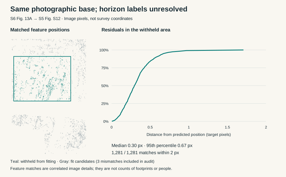
The central area was withheld from fitting. In the 2025 raster this is x = 150–1,190 and y = 330–1,145 pixels, covering the disputed patch and neighboring detail. Matching used reciprocal SIFT descriptor matches with a 0.7 nearest-neighbor ratio in both directions. RANSAC estimated the transform from the remaining matches.
| Check | Result |
|---|---|
| All descriptor-filtered matches | 3,548 |
| Fit candidates outside the withheld rectangle | 2,267; 2,263 RANSAC inliers |
| Withheld matches, with no geometric outlier removal | 1,281 |
| Median withheld positional error | 0.297 target-image pixels |
| 95th-percentile withheld error | 0.673 pixels |
| Largest withheld error | 1.708 pixels |
| Withheld matches within 2 pixels | 1,281 of 1,281 |
Three fit candidates are more than two pixels from their predicted positions; they are retained in the audit, rather than silently removed from the reported candidate statistics. RANSAC’s inlier count and the final transform’s two-pixel count differ by one. The withheld matches occupy 1,142 distinct source positions rounded to 0.1 pixel and 867 target-image cells of 10 × 10 pixels. Detector matches are correlated image details, not independent footprints, people or archaeological observations.
The fitted scale is 0.871563, rotation approximately 0.00015°, and translation −94.865 pixels horizontally / −2.691 pixels vertically. These values describe page-image resizing and cropping. They are not geographic coordinates or evidence of field-survey precision.
Landmark and sensitivity checks
Eight 71 × 71 pixel patches were selected manually after viewing the photographs. Each aligned patch was compared with a ±6 pixel neighborhood in the other image using grayscale normalized cross-correlation. All eight peak at zero additional pixel displacement. These are descriptive checks of selected landmarks, not a random sample or a statistical probability of identity.
| Landmark | Correlation at predicted position | Entire patch withheld from fit? |
|---|---|---|
| Central footprint | 0.948 | Yes |
| Lower groove | 0.982 | Yes |
| Upper groove | 0.958 | Yes |
| Left footprint | 0.926 | Yes |
| Upper footprints | 0.931 | No |
| Right-hand strip | 0.961 | No |
| Trench junction | 0.969 | No |
| Bottle and red marking | 0.978 | No |
A second fit used only 459 matches from the unannotated lower-right photograph, excluding the central patch and the printed horizon labels. It gives a withheld median error of 0.604 pixels and 95th percentile of 0.989 pixels. Its predicted positions differ from the main fit by at most 0.599 pixels at the four withheld-area corners. The full sensitivity results, including the largest error, are retained in the JSON record.
Together, the geometric correspondence, image texture, groove/footprint arrangement and matching excavation details strongly support reuse of the same photographic base. Different figure crops and annotations do not represent two independently documented activity samples.
What remains unresolved
Step 1 establishes photographic correspondence. It does not establish whether TH2 or TH3 is the correct stratigraphic assignment, whether a label was erroneous or deliberately revised, or whether other maps and tables share the discrepancy. It does not register the 2021 3D models to a site map. No footprint ages, counts, feature identifiers or original source labels have been changed.
Review issue WS-SURFACE-001 remains unresolved, with image identity now supported by numerical evidence. The 2025 LF-5 record still has no assigned 2026 horizon or age, and the preservation-adjusted comparison remains blocked.
Step 2 is now documented in the stratigraphic audit. The 2025 detailed section supports a provisional TH3 interpretation, but conflicting overview-plan labels and the missing connection to a 2026 sampled horizon keep the assignment unresolved. A common photograph alone cannot supply that assignment. No author or institution has been contacted.
Sources and reproduction
- S6: Bennett et al. 2025, published paper, Bournemouth PDF, Fig. 13A, PDF p. 14.
- S5: Springer et al. 2026, published paper, Europe PMC supplementary-files endpoint, supplement Fig. S12, PDF p. 28.
Review date: October 28, 2026. The script requires Python, NumPy, OpenCV and Poppler pdfimages; exact execution versions and source hashes are in photographic-registration.json. It checks expected raster dimensions before applying the source-specific masks. Rerun with the same source PDFs and software versions to reproduce the numerical record:
python scripts/register-white-sands-figures.py \
  /path/to/2025-paper.pdf /path/to/2026-supplement.pdf \
  /tmp/photographic-registration.json \
  --plot /tmp/white-sands-photographic-match.svg
The script reads source PDFs without rewriting them. The repository contains the analysis, hashes and a geometry-only diagnostic; it does not redistribute the original PDFs, photographs or blended overlays.